
Thank you for supporting this site ❤️
Make a donation
Make a donation
Galicea topographic map
Click on the map to display elevation.
Thank you for supporting this site ❤️
Make a donation
Make a donation
About this map
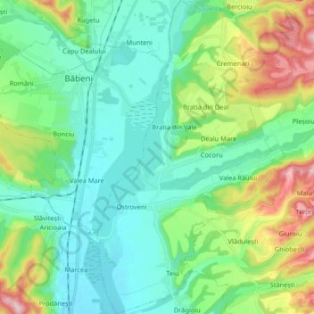
Name: Galicea topographic map, elevation, terrain.
Location: Galicea, Vâlcea, Romania (44.88893 24.24401 45.00383 24.34876)
Average elevation: 248 m
Minimum elevation: 180 m
Maximum elevation: 443 m
Thank you for supporting this site ❤️
Make a donation
Make a donation
Other topographic maps
Click on a map to view its topography, its elevation and its terrain.