
Gdynia topographic map
Interactive map
Click on the map to display elevation.
About this map
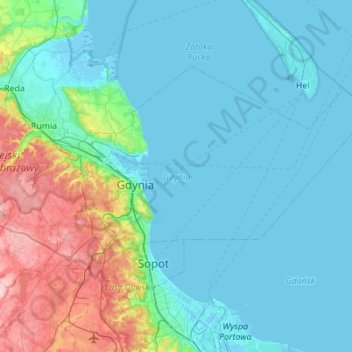
Name: Gdynia topographic map, elevation, terrain.
Location: Gdynia, Pomeranian Voivodeship, Poland (54.42275 18.35798 54.58451 18.56906)
Average elevation: 51 m
Minimum elevation: -4 m
Maximum elevation: 194 m
Other topographic maps
Click on a map to view its topography, its elevation and its terrain.
Pogórze
Poland > Pomeranian Voivodeship > Gdynia
Pogórze, Gdynia, Pomeranian Voivodeship, Poland
Average elevation: 38 m