
Thank you for supporting this site ❤️
Make a donation
Make a donation
Napier topographic map
Click on the map to display elevation.
Thank you for supporting this site ❤️
Make a donation
Make a donation
Napier
The topography puts Napier in danger from a tsunami, as the centre of the commercial city is near sea level – should the sea ever crest Marine Parade, the sea would run through to Ahuriri. Furthermore, by virtue of its pre-1931 existence, the bulk of Napier is susceptible to soil liquefaction, the risk classed as Very High for the main urban area excluding the hill.
Thank you for supporting this site ❤️
Make a donation
Make a donation
About this map
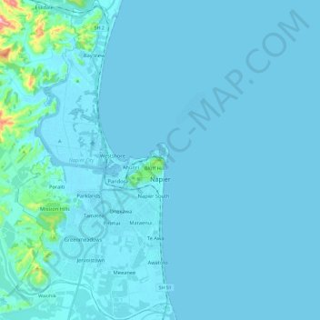
Name: Napier topographic map, elevation, terrain.
Location: Napier, Hawke's Bay, New Zealand (-39.57047 176.81127 -39.38819 176.92593)
Average elevation: 12 m
Minimum elevation: -3 m
Maximum elevation: 276 m
Thank you for supporting this site ❤️
Make a donation
Make a donation
Other topographic maps
Click on a map to view its topography, its elevation and its terrain.
Thank you for supporting this site ❤️
Make a donation
Make a donation
Cape Kidnappers / Te Kauwae-a-Māui
New Zealand > Hawke's Bay > Hastings District
Average elevation: 16 m
Thank you for supporting this site ❤️
Make a donation
Make a donation