
Rullière topographic map
Interactive map
Click on the map to display elevation.
About this map
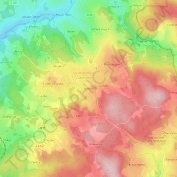
Name: Rullière topographic map, elevation, terrain.
Average elevation: 901 m
Minimum elevation: 763 m
Maximum elevation: 1,013 m
Other topographic maps
Click on a map to view its topography, its elevation and its terrain.
La Croix d'Entraigues
France > Auvergne-Rhône-Alpes > Haute-Loire > Saint-Romain-Lachalm
La Croix d'Entraigues, Saint-Romain-Lachalm, Yssingeaux, Haute-Loire, Auvergne-Rhône-Alpes, France métropolitaine, 43620, France
Average elevation: 860 m