
Thank you for supporting this site ❤️
Make a donation
Make a donation
Kelz topographic map
Click on the map to display elevation.
Thank you for supporting this site ❤️
Make a donation
Make a donation
About this map
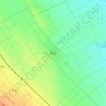
Name: Kelz topographic map, elevation, terrain.
Location: Kelz, Фетвайс, Дюрен, Северный Рейн — Вестфалия, 52391, Германия (50.74815 6.57580 50.78815 6.61580)
Average elevation: 141 m
Minimum elevation: 127 m
Maximum elevation: 161 m
Thank you for supporting this site ❤️
Make a donation
Make a donation
Other topographic maps
Click on a map to view its topography, its elevation and its terrain.