
Charage topographic map
Interactive map
Click on the map to display elevation.
About this map
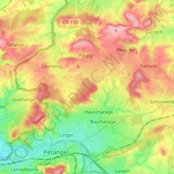
Name: Charage topographic map, elevation, terrain.
Location: Charage, Canton Capellen, Luxembourg (49.54619 5.84777 49.62922 5.95796)
Average elevation: 331 m
Minimum elevation: 262 m
Maximum elevation: 403 m
Other topographic maps
Click on a map to view its topography, its elevation and its terrain.
Bascharage
Bascharage, Charage, Canton Capellen, Luxembourg
Average elevation: 312 m