
Thank you for supporting this site ❤️
Make a donation
Make a donation
Treben topographic map
Click on the map to display elevation.
Thank you for supporting this site ❤️
Make a donation
Make a donation
About this map
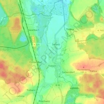
Name: Treben topographic map, elevation, terrain.
Location: Treben, Pleißenaue, Altenburger Land, Thüringen, Deutschland (51.03344 12.40124 51.08471 12.47209)
Average elevation: 165 m
Minimum elevation: 143 m
Maximum elevation: 193 m
Thank you for supporting this site ❤️
Make a donation
Make a donation
Other topographic maps
Click on a map to view its topography, its elevation and its terrain.
Steinsdorf
Deutschland > Thüringen > Altenburger Land > Schmölln > Burkersdorf
Average elevation: 255 m
Thank you for supporting this site ❤️
Make a donation
Make a donation
Thank you for supporting this site ❤️
Make a donation
Make a donation
Thank you for supporting this site ❤️
Make a donation
Make a donation