
Thank you for supporting this site ❤️
Make a donation
Make a donation
Urbana topographic map
Click on the map to display elevation.
Thank you for supporting this site ❤️
Make a donation
Make a donation
About this map
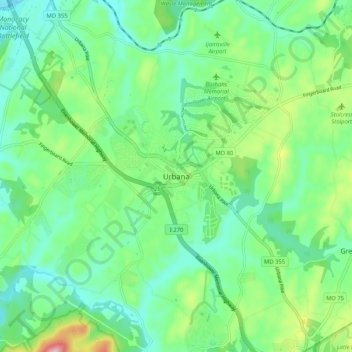
Name: Urbana topographic map, elevation, terrain.
Location: Urbana, Frederick County, Maryland, United States (39.28621 -77.39154 39.36621 -77.31154)
Average elevation: 131 m
Minimum elevation: 70 m
Maximum elevation: 289 m
Thank you for supporting this site ❤️
Make a donation
Make a donation