
Thank you for supporting this site ❤️
Make a donation
Make a donation
Eagan topographic map
Click on the map to display elevation.
Thank you for supporting this site ❤️
Make a donation
Make a donation
About this map
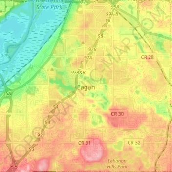
Name: Eagan topographic map, elevation, terrain.
Location: Eagan, Dakota County, Minnesota, United States (44.77563 -93.22787 44.86198 -93.10561)
Average elevation: 267 m
Minimum elevation: 208 m
Maximum elevation: 328 m
Thank you for supporting this site ❤️
Make a donation
Make a donation
Other topographic maps
Click on a map to view its topography, its elevation and its terrain.
Burnsville
United States > Minnesota > Dakota County > Burnsville > Burnsville
Average elevation: 275 m
Thank you for supporting this site ❤️
Make a donation
Make a donation
Farmington
United States > Minnesota > Dakota County > Farmington > Farmington
Average elevation: 280 m
Thank you for supporting this site ❤️
Make a donation
Make a donation