
Iferhounene topographic map
Interactive map
Click on the map to display elevation.
About this map
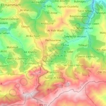
Name: Iferhounene topographic map, elevation, terrain.
Location: Iferhounene, Daïra Iferhounene, Tizi Ouzou, Algérie (36.46617 4.34088 36.57554 4.41354)
Average elevation: 1,097 m
Minimum elevation: 387 m
Maximum elevation: 1,936 m
Other topographic maps
Click on a map to view its topography, its elevation and its terrain.
Imsouhal
Algérie > Tizi Ouzou > Daïra Iferhounene
Imsouhal, Daïra Iferhounene, Tizi Ouzou, 15024, Algérie
Average elevation: 661 m
Illilten
Algérie > Tizi Ouzou > Daïra Iferhounene
Illilten, Daïra Iferhounene, Tizi Ouzou, 15037, Algérie
Average elevation: 1,122 m