
Kortemark topographic map
Interactive map
Click on the map to display elevation.
About this map
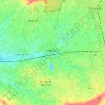
Name: Kortemark topographic map, elevation, terrain.
Location: Kortemark, Diksmuide, West Flanders, 8610, Belgium (50.98402 2.92855 51.07035 3.07040)
Average elevation: 18 m
Minimum elevation: -13 m
Maximum elevation: 49 m
Other topographic maps
Click on a map to view its topography, its elevation and its terrain.
Beerst
Belgium > West Flanders > Diksmuide > Diksmuide
Beerst, Diksmuide, West Flanders, Flanders, 8600, Belgium
Average elevation: 3 m
Diksmuide
Belgium > West Flanders > Diksmuide
Diksmuide, West Flanders, Flanders, 8600, Belgium
Average elevation: 5 m