
Thank you for supporting this site ❤️
Make a donation
Make a donation
Portugual topographic map
Click on the map to display elevation.
Thank you for supporting this site ❤️
Make a donation
Make a donation
About this map
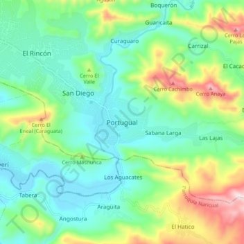
Name: Portugual topographic map, elevation, terrain.
Average elevation: 166 m
Minimum elevation: 13 m
Maximum elevation: 547 m
Thank you for supporting this site ❤️
Make a donation
Make a donation
Other topographic maps
Click on a map to view its topography, its elevation and its terrain.
Puerto La Cruz
Venezuela > Anzoategui State > Municipio Sotillo
The city of Puerto La Cruz is located on the southern shore of the Caribbean. The elevation of the city varies between 767 and 64 metres (2,516 and 210 ft). The city position is at Latitude 10° 13' N and Longitude 64° 37' W. Typical temperatures vary between 25–28 °C (77–82 °F). Borders are represented…
Average elevation: 89 m
Plaza de Chuparín general juan antonio sotillo
Venezuela > Anzoategui State > Municipio Sotillo > Puerto La Cruz
Average elevation: 39 m