
Make a donation
Brussels-Capital topographic map
Click on the map to display elevation.
Make a donation
Brussels-Capital
Brussels lies in the north-central part of Belgium, about 110 km (68 mi) from the Belgian coast and about 180 km (110 mi) from Belgium's southern tip. It is located in the heartland of the Brabantian Plateau, about 45 km (28 mi) south of Antwerp (Flanders), and 50 km (31 mi) north of Charleroi (Wallonia). Its average elevation is 57 m (187 ft) above sea level, varying from a low point in the valley of the almost completely covered Senne, which cuts the Brussels-Capital Region from east to west, up to high points in the Sonian Forest, on its southeastern side. In addition to the Senne, tributary streams such as the Maalbeek and the Woluwe, to the east of the region, account for significant elevation differences. Brussels' central boulevards are 15 m (49 ft) above sea level. Contrary to popular belief, the highest point (at 127.5 m (418 ft)) is not near the Place de l'Altitude Cent/Hoogte Honderdplein in Forest, but at the Drève des Deux Montages/Tweebergendreef in the Sonian Forest.
Make a donation
About this map
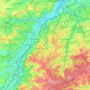
Name: Brussels-Capital topographic map, elevation, terrain.
Location: Brussels-Capital, Belgium (50.76368 4.24377 50.91390 4.48227)
Average elevation: 62 m
Minimum elevation: 10 m
Maximum elevation: 140 m
Make a donation
Other topographic maps
Click on a map to view its topography, its elevation and its terrain.
Make a donation
Bassin de décantation des résidus miniers
Belgium > Liège > Huy > Wanze > Huccorgne > Le Taillis
Average elevation: 133 m
Make a donation
Make a donation
Make a donation
Make a donation
Make a donation
Make a donation
Make a donation
Make a donation
Make a donation
Make a donation
Make a donation
Quatre-Bras de Baisy-Thy
Belgium > Walloon Brabant > Nivelles > Genappe > Baisy-Thy > Quatre-Bras de Baisy-Thy
Average elevation: 146 m
Make a donation
Make a donation
Maasmechelen
Belgium > Limburg > Tongeren > Mechelen-aan-de-Maas > Maasmechelen
The plateau of Campine was built up during the ice age with deposits of sand and other material that the Meuse river had eroded in the upstream Ardennes region. The higher elevation and the proximity of fertile river clay made this location an attractive one for the prehistoric tribes who established…
Average elevation: 48 m
Doode Bemde
Belgium > Flemish Brabant > Leuven > Oud-Heverlee > Sint-Joris-Weert
Average elevation: 48 m
Make a donation
Make a donation
Make a donation
Roodebeek
Belgium > Brussels-Capital > Woluwe-Saint-Lambert - Sint-Lambrechts-Woluwe
Average elevation: 65 m
Make a donation
Make a donation
Make a donation
Marche-en-Famenne
Belgium > Luxembourg > Marche-en-Famenne > Marche-en-Famenne
Average elevation: 252 m
Make a donation
Make a donation
Make a donation
Make a donation
Make a donation