
Hoyerswerda - Wojerecy topographic map
Interactive map
Click on the map to display elevation.
About this map
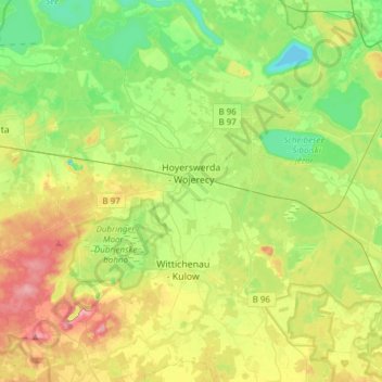
Name: Hoyerswerda - Wojerecy topographic map, elevation, terrain.
Location: Hoyerswerda - Wojerecy, Bautzen, Saxe, 02977, Allemagne (51.38235 14.06556 51.46603 14.37042)
Average elevation: 125 m
Minimum elevation: 83 m
Maximum elevation: 193 m