
Tamworth topographic map
Interactive map
Click on the map to display elevation.
About this map
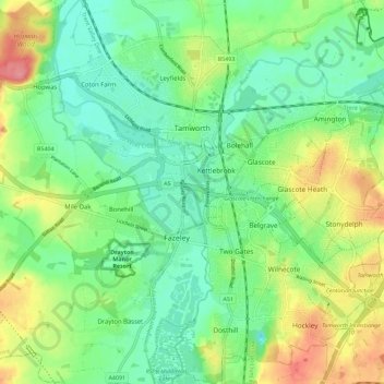
Name: Tamworth topographic map, elevation, terrain.
Location: Tamworth, Staffordshire, England, Vereinigtes Königreich (52.58867 -1.73582 52.65750 -1.63293)
Average elevation: 76 m
Minimum elevation: 47 m
Maximum elevation: 130 m
Other topographic maps
Click on a map to view its topography, its elevation and its terrain.
Leek
Vereinigtes Königreich > England > Staffordshire > Staffordshire Moorlands
Leek, Staffordshire Moorlands, Staffordshire, England, Vereinigtes Königreich
Average elevation: 193 m
The Cloud
Vereinigtes Königreich > England > Staffordshire > Staffordshire Moorlands
The Cloud, Cloudside, Rushton, Staffordshire Moorlands, Staffordshire, England, CW12 3QG, Vereinigtes Königreich
Average elevation: 194 m
Staffordshire Moorlands
Vereinigtes Königreich > England > Staffordshire
Staffordshire Moorlands, Staffordshire, England, Vereinigtes Königreich
Average elevation: 227 m
Farley
Vereinigtes Königreich > England > Staffordshire > Staffordshire Moorlands
Farley, Staffordshire Moorlands, Staffordshire, England, Vereinigtes Königreich
Average elevation: 221 m
Quarnford
Vereinigtes Königreich > England > Staffordshire > Staffordshire Moorlands > Flash
Quarnford, Flash, Staffordshire Moorlands, Staffordshire, England, Vereinigtes Königreich
Average elevation: 408 m
Staffordshire
Vereinigtes Königreich > England > Staffordshire
Staffordshire, West Midlands, England, Vereinigtes Königreich
Average elevation: 130 m
Burton-on-Trent
Vereinigtes Königreich > England > Staffordshire > East Staffordshire
Burton-on-Trent, East Staffordshire, Staffordshire, England, DE14 1JN, Vereinigtes Königreich
Average elevation: 69 m