
Hoge Hexel topographic map
Interactive map
Click on the map to display elevation.
About this map
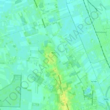
Name: Hoge Hexel topographic map, elevation, terrain.
Location: Hoge Hexel, Wierden, Overijssel, Nederland (52.37877 6.50854 52.41751 6.59670)
Average elevation: 10 m
Minimum elevation: 5 m
Maximum elevation: 23 m
Other topographic maps
Click on a map to view its topography, its elevation and its terrain.
Regge
Nederland > Overijssel > Wierden
Regge, Wierden, Overijssel, Nederland, 7468, Nederland
Average elevation: 11 m
Notter
Nederland > Overijssel > Wierden
Notter, Wierden, Overijssel, Nederland, 7467 PL, Nederland
Average elevation: 11 m
Hoge Hexel
Nederland > Overijssel > Wierden > Hoge Hexel
Hoge Hexel, Wierden, Overijssel, Nederland, 7645, Nederland
Average elevation: 10 m