
Thank you for supporting this site ❤️
Make a donation
Make a donation
Cataract topographic map
Click on the map to display elevation.
Thank you for supporting this site ❤️
Make a donation
Make a donation
About this map
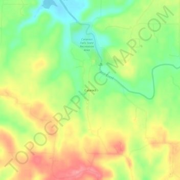
Name: Cataract topographic map, elevation, terrain.
Location: Cataract, Owen County, Indiana, United States (39.40755 -86.83640 39.44755 -86.79640)
Average elevation: 239 m
Minimum elevation: 194 m
Maximum elevation: 285 m
Thank you for supporting this site ❤️
Make a donation
Make a donation
Other topographic maps
Click on a map to view its topography, its elevation and its terrain.