
Thank you for supporting this site ❤️
Make a donation
Make a donation
Hatfield topographic map
Click on the map to display elevation.
Thank you for supporting this site ❤️
Make a donation
Make a donation
About this map
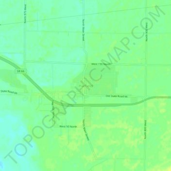
Name: Hatfield topographic map, elevation, terrain.
Location: Hatfield, Spencer County, Indiana, 47617, United States (37.88484 -87.24362 37.92484 -87.20362)
Average elevation: 117 m
Minimum elevation: 109 m
Maximum elevation: 125 m
Thank you for supporting this site ❤️
Make a donation
Make a donation
Other topographic maps
Click on a map to view its topography, its elevation and its terrain.