
Thank you for supporting this site ❤️
Make a donation
Make a donation
Kamikochi topographic map
Click on the map to display elevation.
Thank you for supporting this site ❤️
Make a donation
Make a donation
Kamikochi
Kamikōchi is a high mountain valley approximately 18 kilometers in length. The average elevation of the valley floor ranges between roughly 1,400 m (4,600 ft) above sea level at the south end and roughly 1,600 m (5,200 ft) at the northern tip.
Thank you for supporting this site ❤️
Make a donation
Make a donation
About this map
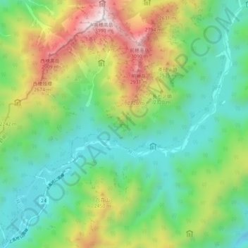
Name: Kamikochi topographic map, elevation, terrain.
Location: Kamikochi, Matsumoto, Nagano Prefecture, Japan (36.22406 137.61236 36.29451 137.69723)
Average elevation: 2,006 m
Minimum elevation: 1,439 m
Maximum elevation: 3,185 m
Thank you for supporting this site ❤️
Make a donation
Make a donation