
Thank you for supporting this site ❤️
Make a donation
Make a donation
Rakhiv topographic map
Click on the map to display elevation.
Thank you for supporting this site ❤️
Make a donation
Make a donation
Rakhiv
With an elevation of 430 meters above sea level, Rakhiv is Ukraine's highest city.
Thank you for supporting this site ❤️
Make a donation
Make a donation
About this map
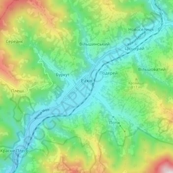
Name: Rakhiv topographic map, elevation, terrain.
Average elevation: 669 m
Minimum elevation: 414 m
Maximum elevation: 1,255 m
Thank you for supporting this site ❤️
Make a donation
Make a donation