
Guitiriz topographic map
Interactive map
Click on the map to display elevation.
About this map
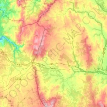
Name: Guitiriz topographic map, elevation, terrain.
Location: Guitiriz, Terra Chá, Lugo, Galice, Espagne (43.09228 -7.96100 43.33579 -7.68938)
Average elevation: 501 m
Minimum elevation: 243 m
Maximum elevation: 790 m
Other topographic maps
Click on a map to view its topography, its elevation and its terrain.
Baltar
Espagne > Galice > Terra Chá > A Pastoriza
Baltar, A Pastoriza, Terra Chá, Lugo, Galice, Espagne
Average elevation: 462 m
Castro de Rei
Espagne > Galice > Terra Chá > Castro de Rei
Castro de Rei, Terra Chá, Lugo, Galice, Espagne
Average elevation: 505 m