
Thank you for supporting this site ❤️
Make a donation
Make a donation
Stadel topographic map
Click on the map to display elevation.
Thank you for supporting this site ❤️
Make a donation
Make a donation
About this map
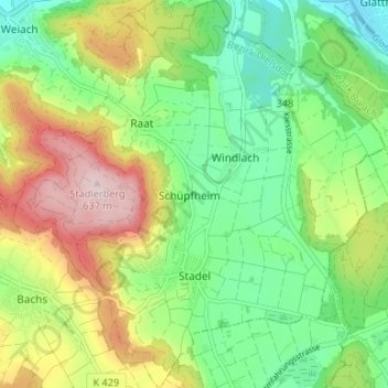
Name: Stadel topographic map, elevation, terrain.
Location: Stadel, Bezirk Dielsdorf, Zurich, Suisse (47.51511 8.43998 47.55991 8.50021)
Average elevation: 467 m
Minimum elevation: 354 m
Maximum elevation: 647 m
Thank you for supporting this site ❤️
Make a donation
Make a donation
Other topographic maps
Click on a map to view its topography, its elevation and its terrain.