
Sandringham topographic map
Interactive map
Click on the map to display elevation.
About this map
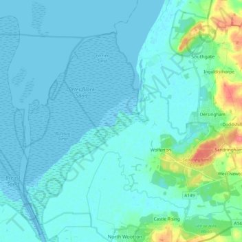
Name: Sandringham topographic map, elevation, terrain.
Average elevation: 8 m
Minimum elevation: -2 m
Maximum elevation: 61 m
Other topographic maps
Click on a map to view its topography, its elevation and its terrain.
North Runcton
Royaume-Uni > Angleterre > Norfolk > King's Lynn and West Norfolk
North Runcton, King's Lynn and West Norfolk, Norfolk, Angleterre, Royaume-Uni
Average elevation: 12 m
Castle Acre
Royaume-Uni > Angleterre > Norfolk > King's Lynn and West Norfolk > Castle Acre
Castle Acre, King's Lynn and West Norfolk, Norfolk, East of England, Angleterre, Royaume-Uni
Average elevation: 60 m