
Chaozhou topographic map
Interactive map
Click on the map to display elevation.
About this map
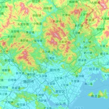
Name: Chaozhou topographic map, elevation, terrain.
Location: Chaozhou, Guangdong, China (23.43026 116.36107 24.22709 117.24948)
Average elevation: 228 m
Minimum elevation: -2 m
Maximum elevation: 1,488 m
Other topographic maps
Click on a map to view its topography, its elevation and its terrain.
江村
China > Guangdong > Huizhou City > 江村
江村, Huizhou City, Huidong County, Guangdong, China
Average elevation: 60 m
Nanhu Sub-district
China > Guangdong > Shenzhen City > Nanhu Sub-district
Nanhu Sub-district, Luohu District, Shenzhen City, Guangdong, 518000, China
Average elevation: 29 m