Geolocate

Bright topographic map

Interactive map

Click on the map to display elevation.

About this map

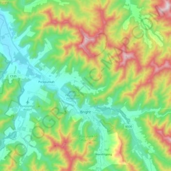
Name: Bright topographic map, elevation, terrain.

Location: Bright, Alpine Shire, Victoria, 3741, Australia (-36.77697 146.92749 -36.62824 147.13629)

Average elevation: 550 m

Minimum elevation: 245 m

Maximum elevation: 1,204 m

Other topographic maps

Click on a map to view its topography, its elevation and its terrain.

Carlsruhe

Australia > Victoria

Average elevation: 533 m

Bendigo

Australia > Victoria

Average elevation: 223 m

Taggerty

Australia > Victoria

Average elevation: 234 m

Geelong

Australia > Victoria > Geelong

Average elevation: 42 m

Healesville

Australia > Victoria > Healesville

Average elevation: 150 m

Mount Bogong

Australia > Victoria

Average elevation: 1,719 m