
Asundi topographic map
Interactive map
Click on the map to display elevation.
About this map
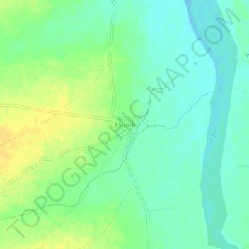
Name: Asundi topographic map, elevation, terrain.
Location: Asundi, Bellary taluk, Ballari District, Karnataka, India (15.09205 77.01388 15.13205 77.05388)
Average elevation: 419 m
Minimum elevation: 409 m
Maximum elevation: 432 m
Other topographic maps
Click on a map to view its topography, its elevation and its terrain.
Yalpi
India > Karnataka > Bellary taluk
Yalpi, Bellary taluk, Ballari District, Karnataka, India
Average elevation: 419 m
Ballari
India > Karnataka > Bellary taluk
Ballari, Bellary taluk, Ballari District, Karnataka, 583101, India
Average elevation: 470 m
Banapura
India > Karnataka > Bellary taluk
Banapura, Bellary taluk, Ballari District, Karnataka, India
Average elevation: 400 m