
Thank you for supporting this site ❤️
Make a donation
Make a donation
Châtaignier topographic map
Click on the map to display elevation.
Thank you for supporting this site ❤️
Make a donation
Make a donation
About this map
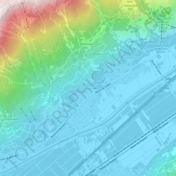
Name: Châtaignier topographic map, elevation, terrain.
Location: Châtaignier, Fully, Martigny, Valais, 1926, Suisse (46.12569 7.10486 46.16569 7.14486)
Average elevation: 742 m
Minimum elevation: 455 m
Maximum elevation: 2,089 m
Thank you for supporting this site ❤️
Make a donation
Make a donation
Other topographic maps
Click on a map to view its topography, its elevation and its terrain.