
Make a donation
Pasco County topographic map
Click on the map to display elevation.
Make a donation
Pasco County
A portion of Eastern Pasco County contains rolling topography with elevations from 100 to 160 ft (30 to 49 m), along with San Antonio and St. Leo.
Make a donation
About this map
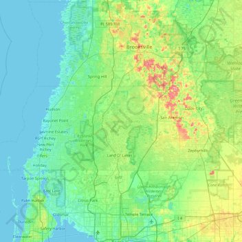
Name: Pasco County topographic map, elevation, terrain.
Location: Pasco County, Florida, United States (28.16993 -82.90831 28.47884 -82.05469)
Average elevation: 18 m
Minimum elevation: -1 m
Maximum elevation: 92 m
Make a donation
Other topographic maps
Click on a map to view its topography, its elevation and its terrain.
Jacksonville
United States > Florida > Duval County > Jacksonville
Just south of Jacksonville and north of Saint Augustine is the boundary of where the Floridian Peninsula ends and Continental North America begins; Jacksonville is north of that line. While still in the North American Coastal plain, the topography begins to take on slight Piedmont characteristics. Like the…
Average elevation: 9 m
Make a donation
Highland Woods Golf & Country Club
United States > Florida > Lee County > Bonita Springs
Average elevation: 5 m