
Mora topographic map
Interactive map
Click on the map to display elevation.
About this map
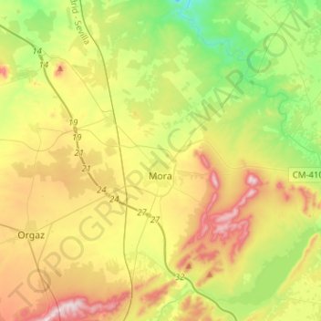
Name: Mora topographic map, elevation, terrain.
Average elevation: 717 m
Minimum elevation: 546 m
Maximum elevation: 961 m
Die Kleinstadt Mora liegt gut 36 km (Fahrtstrecke) südöstlich von Toledo in der historischen Provinz La Mancha in einer Höhe von ca. 715 m; bis nach Madrid sind es knapp 100 km in nördlicher Richtung. Die nächstgrößeren Orte sind Orgaz (ca. 14 km südwestlich) und Sonseca (ca. 22 km westlich). Das Klima im Winter ist rau, im Sommer dagegen trocken und warm; der spärliche Regen (ca. 430 mm/Jahr) fällt überwiegend in den Wintermonaten.