
Make a donation
Lumbini Province topographic map
Click on the map to display elevation.
Make a donation
Lumbini Province
The elevations of Dang and Deukhuri valleys are 700 meters and 300 meters from sea level respectively. Late Cenozoic sedimentary sequences are well exposed along the southern part of Dang and all sides of Deukhuri valley, and mostly consist of deformed rocks resulting from the persistence of shortening between Indian Plate and Eurasian Plate. The two valleys have been considered a vital location of Paleolithic archeology in South Asia due to the abundant presence of ancient Paleolithic tool sites.
Make a donation
About this map
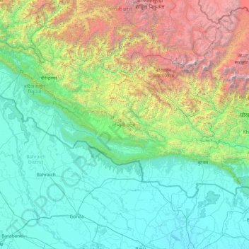
Name: Lumbini Province topographic map, elevation, terrain.
Location: Lumbini Province, Nepal (27.33016 81.05977 28.86928 84.02844)
Average elevation: 1,417 m
Minimum elevation: 72 m
Maximum elevation: 8,008 m
Make a donation
Other topographic maps
Click on a map to view its topography, its elevation and its terrain.
Lhotse
Nepal > Koshi Province > Solukhumbu
Lhotse (Nepali: ल्होत्से, romanized: L'hōtsē [lotse]; Standard Tibetan: ལྷོ་རྩེ, romanized: lho tse, lit. 'South Peak' [l̥otse]; Chinese: 洛子峰) is the fourth-highest mountain on Earth, after Mount Everest, K2, and Kangchenjunga. At an elevation of 8,516 metres (27,940…
Average elevation: 7,391 m
Manaslu
Nepal > Gandaki Province > Gorkha
The Manaslu region offers a variety of trekking options. The popular Manaslu trekking route of 177 kilometres (110 mi) skirts the Manaslu massif over the pass down to Annapurna. The Nepalese Government only permitted trekking on this circuit in 1991. The trekking trail follows an ancient salt-trading route…
Average elevation: 7,069 m
Make a donation
Make a donation
Jomsom
Nepal > Gandaki Province > Mustang
Jomsom (Nepali: जोमसोम), (Ward No. 4 of Gharpajhong Rural Municipality) also known as Dzongsam (New Fort), is the centre of Gharapjhong rural municipality in Mustang district and a former independent village development committee situated at an altitude of about 2,700 metres (8,900 ft) in Gandaki…
Average elevation: 3,061 m
Make a donation
Make a donation
Make a donation
Make a donation
Gokyo
Nepal > Koshi Province > Solukhumbu
The village is located at an elevation of 4,750 m (15,584 ft), making it one of the highest settlements in Nepal and in the world. Almost all the buildings are guest houses for trekkers. The people who live in the village leave during the winter and move to other (lower) villages such as Namche Bazaar.
Average elevation: 4,919 m
Make a donation
Ilam
Nepal > Koshi Province > Ilam
The word ‘Ilam’ comprises two words-‘I’ and ‘Lam’. In Limbu language, the word ‘I’ means ‘winding’ and ‘lam’ denotes the way. The topography of this Ilam aptly depicts several winding paths crisscrossing.
Average elevation: 919 m
Make a donation
Make a donation
Phaplu
Nepal > Koshi Province > Solukhumbu
Phaphlu is a mountainous town in north-east Nepal, approximately 270 kilometres east of the Nepalese capital, Kathmandu. The altitude of the village is 2,413 m.
Average elevation: 2,518 m
Western Development Region
The Western Development Region (Nepali: पश्चिमाञ्चल विकास क्षेत्र, Pashchimānchal Bikās Kshetra) was one of Nepal's five development regions. It was located in the west-central part of the country, with its headquarters located in Pokhara. This Development Region…
Average elevation: 2,742 m
Make a donation
Make a donation
Make a donation
Make a donation
Make a donation
Lukla
Nepal > Koshi Province > Solukhumbu
Lukla village holds a small airport serving the region, and a variety of shops and lodges catering to tourists and trekkers, providing western-style meals and trail supplies. From Lukla, travelers need two days to reach the village of Namche Bazaar, an altitude-acclimatization stop for those continuing on. The…
Average elevation: 2,996 m
Make a donation
Make a donation