
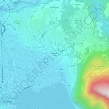
Domaine St Laurent topographic map
Interactive map
Click on the map to display elevation.
About this map
Name: Domaine St Laurent topographic map, elevation, terrain.
Average elevation: 550 m
Minimum elevation: 436 m
Maximum elevation: 1,257 m
Other topographic maps
Click on a map to view its topography, its elevation and its terrain.
Résidence Louis Armand
France > Auvergne-Rhône-Alpes > Haute-Savoie > Annecy > Domaine St Laurent
Résidence Louis Armand, Domaine St Laurent, Annecy-le-Vieux, Annecy, Haute-Savoie, Auvergne-Rhône-Alpes, France métropolitaine, 74940, France
Average elevation: 541 m