
Thank you for supporting this site ❤️
Make a donation
Make a donation
Choeng Mon topographic map
Click on the map to display elevation.
Thank you for supporting this site ❤️
Make a donation
Make a donation
About this map
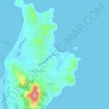
Name: Choeng Mon topographic map, elevation, terrain.
Location: Choeng Mon, Ko Samui, Surat Thani Province, 84240, Thailand (9.55117 100.06045 9.59117 100.10045)
Average elevation: 15 m
Minimum elevation: -1 m
Maximum elevation: 183 m
Thank you for supporting this site ❤️
Make a donation
Make a donation
Other topographic maps
Click on a map to view its topography, its elevation and its terrain.
Thank you for supporting this site ❤️
Make a donation
Make a donation