
Leicestershire topographic map
Interactive map
Click on the map to display elevation.
About this map
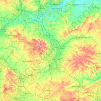
Name: Leicestershire topographic map, elevation, terrain.
Location: Leicestershire, Inglaterra, Reino Unido (52.39217 -1.59755 52.97766 -0.66411)
Average elevation: 98 m
Minimum elevation: 16 m
Maximum elevation: 269 m
Other topographic maps
Click on a map to view its topography, its elevation and its terrain.
Leicester
Reino Unido > Inglaterra > Leicestershire
Leicester, Leicestershire, Inglaterra, LE1 5YA, Reino Unido
Average elevation: 109 m