
Thank you for supporting this site ❤️
Make a donation
Make a donation
Krishnarajapete topographic map
Click on the map to display elevation.
Thank you for supporting this site ❤️
Make a donation
Make a donation
Krishnarajapete
Krishnarajpet is located at 12°40′N 76°29′E / 12.66°N 76.49°E / 12.66; 76.49. It has an average elevation of 790 metres (2591 feet).
Thank you for supporting this site ❤️
Make a donation
Make a donation
About this map
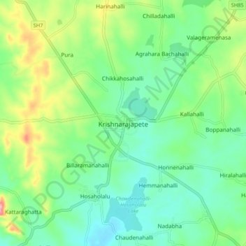
Name: Krishnarajapete topographic map, elevation, terrain.
Average elevation: 819 m
Minimum elevation: 777 m
Maximum elevation: 915 m
Thank you for supporting this site ❤️
Make a donation
Make a donation