
North 24 Parganas topographic map
Interactive map
Click on the map to display elevation.
About this map
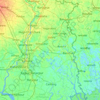
Name: North 24 Parganas topographic map, elevation, terrain.
Location: North 24 Parganas, West Bengal, India (22.12918 88.32947 23.25661 89.09645)
Average elevation: 6 m
Minimum elevation: -4 m
Maximum elevation: 25 m
Other topographic maps
Click on a map to view its topography, its elevation and its terrain.
Bangar
India > West Bengal > Bangar
Bangar, Bhangar - I, South 24 Parganas, West Bengal, 743502, India
Average elevation: 4 m
Bagdogra
India > West Bengal > Bagdogra
Bagdogra, Darjiling, Darjeeling, West Bengal, India
Average elevation: 136 m
Gayespur
India > West Bengal > Gayespur
Gayespur, Nadia, West Bengal, 741234, India
Average elevation: 10 m
Kharagpur
India > West Bengal > Kharagpur
Kharagpur, Kharagpur-I, Paschim Medinipur, West Bengal, 721301, India
Average elevation: 39 m
Shantipur
India > West Bengal > Shantipur
Shantipur, Nadia, West Bengal, 741404, India
Average elevation: 11 m