
Thank you for supporting this site ❤️
Make a donation
Make a donation
Gabbs topographic map
Click on the map to display elevation.
Thank you for supporting this site ❤️
Make a donation
Make a donation
About this map
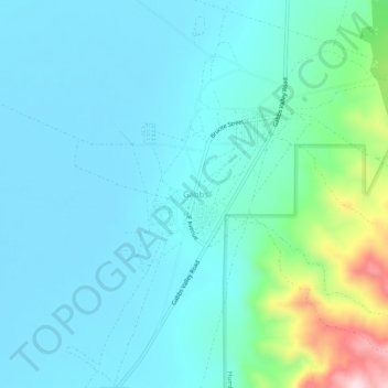
Name: Gabbs topographic map, elevation, terrain.
Location: Gabbs, Nye County, Nevada, 89409, United States (38.84929 -117.94262 38.88929 -117.90262)
Average elevation: 1,466 m
Minimum elevation: 1,381 m
Maximum elevation: 1,850 m
Thank you for supporting this site ❤️
Make a donation
Make a donation
Other topographic maps
Click on a map to view its topography, its elevation and its terrain.