
Make a donation
Madathukulam topographic map
Click on the map to display elevation.
Make a donation
About this map
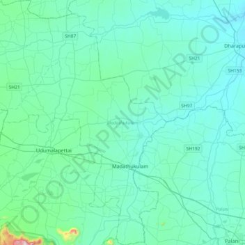
Name: Madathukulam topographic map, elevation, terrain.
Location: Madathukulam, Tiruppur District, Tamil Nadu, India (10.44548 77.13469 10.80342 77.41750)
Average elevation: 328 m
Minimum elevation: 234 m
Maximum elevation: 1,203 m
Make a donation
Other topographic maps
Click on a map to view its topography, its elevation and its terrain.
Tenkasi
India > Tamil Nadu > Tenkasi
Tenkasi is located at 8°58′N 77°18′E / 8.97°N 77.3°E / 8.97; 77.3. It has an average elevation of 143 metres (469 ft). The town is surrounded by the Western Ghats in three sides and lies on the Tirunelveli to Kollam and Madurai to Kollam highways. The Chittar river flows through the city.
Average elevation: 170 m
Make a donation
Make a donation
Make a donation
Avadi
India > Tamil Nadu > Poonamallee
Avadi is located at 13°07′N 80°06′E / 13.12°N 80.1°E / 13.12; 80.1.[6] It covers an area of 65 square kilometres (25 sq mi) and has an average elevation of 17 metres (56 ft).
Average elevation: 23 m