
Thank you for supporting this site ❤️
Make a donation
Make a donation
Avadi topographic map
Click on the map to display elevation.
Thank you for supporting this site ❤️
Make a donation
Make a donation
Avadi
Avadi is located at 13°07′N 80°06′E / 13.12°N 80.1°E / 13.12; 80.1.[6] It covers an area of 65 square kilometres (25 sq mi) and has an average elevation of 17 metres (56 ft).
Thank you for supporting this site ❤️
Make a donation
Make a donation
About this map
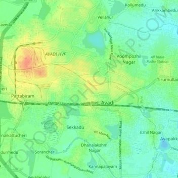
Name: Avadi topographic map, elevation, terrain.
Average elevation: 23 m
Minimum elevation: -1 m
Maximum elevation: 137 m
Thank you for supporting this site ❤️
Make a donation
Make a donation
Other topographic maps
Click on a map to view its topography, its elevation and its terrain.