
Thank you for supporting this site ❤️
Make a donation
Make a donation
Indre Hornindal topographic map
Click on the map to display elevation.
Thank you for supporting this site ❤️
Make a donation
Make a donation
About this map
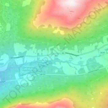
Name: Indre Hornindal topographic map, elevation, terrain.
Location: Indre Hornindal, Volda, Мёре-ог-Ромсдал, Норвегия (61.97827 6.58246 62.01827 6.62246)
Average elevation: 452 m
Minimum elevation: 187 m
Maximum elevation: 999 m
Thank you for supporting this site ❤️
Make a donation
Make a donation
Other topographic maps
Click on a map to view its topography, its elevation and its terrain.