
Thank you for supporting this site ❤️
Make a donation
Make a donation
Saint-M'Hervon topographic map
Click on the map to display elevation.
Thank you for supporting this site ❤️
Make a donation
Make a donation
About this map
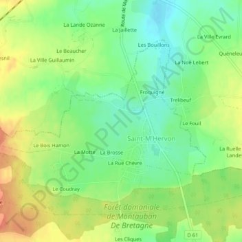
Name: Saint-M'Hervon topographic map, elevation, terrain.
Average elevation: 92 m
Minimum elevation: 70 m
Maximum elevation: 118 m
Thank you for supporting this site ❤️
Make a donation
Make a donation
Other topographic maps
Click on a map to view its topography, its elevation and its terrain.
Thank you for supporting this site ❤️
Make a donation
Make a donation
Le Champ du Moulin
France > Bretagne > Ille-et-Vilaine > Montauban-de-Bretagne
Average elevation: 83 m