
Cameron Highlands topographic map
Click on the map to display elevation.
Cameron Highlands
Surveyed by the government geologist and explorer William Cameron in 1885, the outpost consists of three mukims (subdistricts), namely Ringlet, Tanah Rata and Ulu Telom. Its eight settlements are Ringlet, Tanah Rata (the administrative centre), Brinchang, the Bertam Valley, Kea Farm, Tringkap, Kampung Kuala Terla, Kampung Raja and Blue Valley. All are nestled at elevations ranging from 800 metres (2,600 ft) to 1,603 metres (5,259 ft) above sea level.
About this map
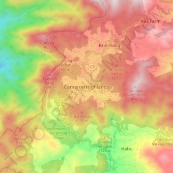
Name: Cameron Highlands topographic map, elevation, terrain.
Location: Cameron Highlands, Pahang, 39000, Malaysia (4.43243 101.33786 4.51243 101.41786)
Average elevation: 1,400 m
Minimum elevation: 823 m
Maximum elevation: 1,849 m
Other topographic maps
Click on a map to view its topography, its elevation and its terrain.