
Thank you for supporting this site ❤️
Make a donation
Make a donation
Montblesson topographic map
Click on the map to display elevation.
Thank you for supporting this site ❤️
Make a donation
Make a donation
About this map
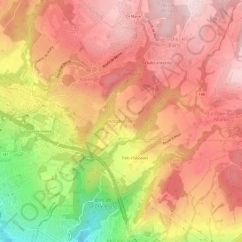
Name: Montblesson topographic map, elevation, terrain.
Location: Montblesson, Lausanne, District de Lausanne, Vaud, 1068, Suisse (46.52031 6.66012 46.56031 6.70012)
Average elevation: 746 m
Minimum elevation: 506 m
Maximum elevation: 880 m
Thank you for supporting this site ❤️
Make a donation
Make a donation
Other topographic maps
Click on a map to view its topography, its elevation and its terrain.