
Make a donation
Kutztown topographic map
Click on the map to display elevation.
Make a donation
About this map
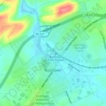
Name: Kutztown topographic map, elevation, terrain.
Location: Kutztown, Berks County, Pennsylvania, United States (40.50884 -75.79863 40.53458 -75.76387)
Average elevation: 142 m
Minimum elevation: 119 m
Maximum elevation: 205 m
Make a donation
Other topographic maps
Click on a map to view its topography, its elevation and its terrain.
Maple Grove Park
United States > Pennsylvania > Berks County > Brecknock Township
Average elevation: 198 m
Make a donation
Make a donation
Tulpehocken Creek
United States > Pennsylvania > Berks County > Penn Township > Pleasant Valley
Average elevation: 111 m
11th and Pike Playground
United States > Pennsylvania > Berks County > Reading
Average elevation: 132 m
Hamburg Reservoir
United States > Pennsylvania > Berks County > Windsor Township
Average elevation: 339 m
Make a donation
Make a donation
Make a donation
Shartlesville
United States > Pennsylvania > Berks County > Upper Bern Township
Average elevation: 183 m
Make a donation
Spring Ridge
United States > Pennsylvania > Berks County > Spring Township > Spring Ridge
Average elevation: 98 m
Make a donation
Barto
United States > Pennsylvania > Berks County > Washington Township > Barto
Average elevation: 174 m
Blue Marsh Bernville Levee
United States > Pennsylvania > Berks County > Bernville
Average elevation: 111 m