
Thank you for supporting this site ❤️
Make a donation
Make a donation
McArt's Fort topographic map
Click on the map to display elevation.
Thank you for supporting this site ❤️
Make a donation
Make a donation
About this map
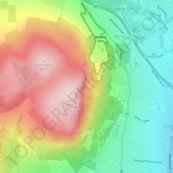
Name: McArt's Fort topographic map, elevation, terrain.
Average elevation: 165 m
Minimum elevation: 3 m
Maximum elevation: 364 m
Thank you for supporting this site ❤️
Make a donation
Make a donation
Other topographic maps
Click on a map to view its topography, its elevation and its terrain.
Lagan Navigation (Abandoned)
United Kingdom > Northern Ireland > County Antrim > Belfast
Average elevation: 29 m
Thank you for supporting this site ❤️
Make a donation
Make a donation