
Thank you for supporting this site ❤️
Make a donation
Make a donation
Madera Canyon topographic map
Click on the map to display elevation.
Thank you for supporting this site ❤️
Make a donation
Make a donation
About this map
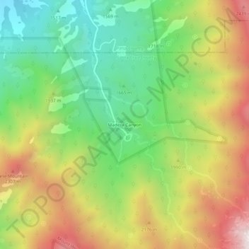
Name: Madera Canyon topographic map, elevation, terrain.
Location: Madera Canyon, Santa Cruz County, Arizona, United States (31.69508 -110.89478 31.73508 -110.85478)
Average elevation: 1,882 m
Minimum elevation: 1,342 m
Maximum elevation: 2,595 m
Thank you for supporting this site ❤️
Make a donation
Make a donation
Other topographic maps
Click on a map to view its topography, its elevation and its terrain.
Nogales
United States > Arizona > Santa Cruz County
The city is at an elevation of 3,829 feet (1,167 m).
Average elevation: 1,192 m
Thank you for supporting this site ❤️
Make a donation
Make a donation
Thank you for supporting this site ❤️
Make a donation
Make a donation
Thank you for supporting this site ❤️
Make a donation
Make a donation
Nogales
United States > Arizona > Santa Cruz County
The city is at an elevation of 3,829 ft (1,167 m).
Average elevation: 1,192 m