
Make a donation
Harding Crossing topographic map
Click on the map to display elevation.
Make a donation
About this map
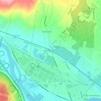
Name: Harding Crossing topographic map, elevation, terrain.
Average elevation: 100 m
Minimum elevation: 60 m
Maximum elevation: 200 m
Make a donation
Other topographic maps
Click on a map to view its topography, its elevation and its terrain.
Town of Duanesburg
United States > New York > Schenectady County
The town consists of mostly wooded hills up to an elevation of approximately 1,400 feet (430 m) above sea level. Most of the town was cleared farmland until the late 20th century. After this point forests grew to cover 60% of the total land area with a canopy higher than 40 feet (12 m). The forest is primary…
Average elevation: 276 m
Make a donation
Village of Delanson
United States > New York > Schenectady County > Town of Duanesburg
Average elevation: 290 m
Make a donation
Make a donation
Town of Duanesburg
United States > New York > Schenectady County
The town consists of mostly wooded hills up to an elevation of approximately 1,400 feet (430 m) above sea level. Most of the town was cleared farmland until the late 20th century. After this point forests grew to cover 60% of the total land area with a canopy higher than 40 feet (12 m). The forest is primary…
Average elevation: 276 m
Make a donation
Village of Delanson
United States > New York > Schenectady County > Town of Duanesburg
Average elevation: 290 m