
Thank you for supporting this site ❤️
Make a donation
Make a donation
Sinoe topographic map
Click on the map to display elevation.
Thank you for supporting this site ❤️
Make a donation
Make a donation
About this map
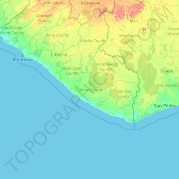
Name: Sinoe topographic map, elevation, terrain.
Location: Sinoe, Liberia (2.72327 -11.44360 7.92327 -6.24360)
Average elevation: 114 m
Minimum elevation: 0 m
Maximum elevation: 1,644 m
Thank you for supporting this site ❤️
Make a donation
Make a donation
Other topographic maps
Click on a map to view its topography, its elevation and its terrain.
Thank you for supporting this site ❤️
Make a donation
Make a donation
Thank you for supporting this site ❤️
Make a donation
Make a donation
Thank you for supporting this site ❤️
Make a donation
Make a donation
Grand Kru County
The residents have a subsistence farming economy, based on slash-and-burn techniques of clearing the bush. The most important crops are upland rice, cassava, palm nuts, and along the coast, fishing. Feed maize is grown at higher elevations farther inland. Sugar cane and several varieties of bananas grow in the…
Average elevation: 61 m
Thank you for supporting this site ❤️
Make a donation
Make a donation
Thank you for supporting this site ❤️
Make a donation
Make a donation
Thank you for supporting this site ❤️
Make a donation
Make a donation
Thank you for supporting this site ❤️
Make a donation
Make a donation
Thank you for supporting this site ❤️
Make a donation
Make a donation
Thank you for supporting this site ❤️
Make a donation
Make a donation
Thank you for supporting this site ❤️
Make a donation
Make a donation