
Make a donation
Lateis / Latais topographic map
Click on the map to display elevation.
Make a donation
About this map
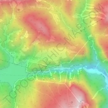
Name: Lateis / Latais topographic map, elevation, terrain.
Average elevation: 1,258 m
Minimum elevation: 717 m
Maximum elevation: 1,790 m
Make a donation
Other topographic maps
Click on a map to view its topography, its elevation and its terrain.
Torreano / Torean / Tavorjana
Italy > Friuli – Venezia Giulia > Udine / Udin / Videm
Average elevation: 448 m
San Pietro al Natisone
Italy > Friuli – Venezia Giulia > Udine / Udin / Videm
Average elevation: 355 m
Make a donation
Tarvisio / Tarvis / Trbiž
Italy > Friuli – Venezia Giulia > Udine / Udin / Videm
Average elevation: 1,268 m
Pontebba / Ponteibe / Pontafel / Tablija
Italy > Friuli – Venezia Giulia > Udine / Udin / Videm
Average elevation: 1,289 m
Make a donation
Basiliano / Pasian Sclavonesc
Italy > Friuli – Venezia Giulia > Udine / Udin / Videm
The municipality is located in the Middle Friuli region, on the high Friulian plain, at an average altitude of 77 meters above sea level, and is approximately 13 km from both Udine and Codroipo.
Average elevation: 76 m
Sauris / Zahre
Italy > Friuli – Venezia Giulia > Udine / Udin / Videm
Sauris (German: Zahre) is a comune (municipality) in the Regional decentralization entity of Udine in the Italian region of Friuli-Venezia Giulia. At an elevation of 1,212 m (3,976 ft), it is the second highest municipality in the region and one of the German language islands in Northeast Italy. Sauris is part…
Average elevation: 1,467 m
Make a donation
Tarvisio / Tarvis / Trbiž
Italy > Friuli – Venezia Giulia > Udine / Udin / Videm
Average elevation: 1,268 m
Make a donation