
Thank you for supporting this site ❤️
Make a donation
Make a donation
Bambe topographic map
Click on the map to display elevation.
Thank you for supporting this site ❤️
Make a donation
Make a donation
About this map
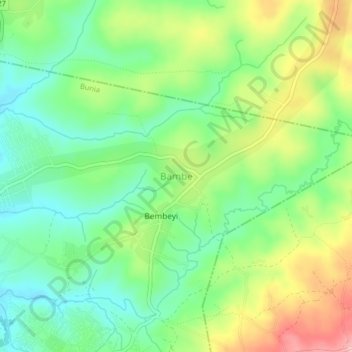
Name: Bambe topographic map, elevation, terrain.
Location: Bambe, Bunia, Ituri, Democratic Republic of the Congo (1.57278 30.27333 1.61278 30.31333)
Average elevation: 1,314 m
Minimum elevation: 1,258 m
Maximum elevation: 1,405 m
Thank you for supporting this site ❤️
Make a donation
Make a donation
Other topographic maps
Click on a map to view its topography, its elevation and its terrain.