
Thank you for supporting this site ❤️
Make a donation
Make a donation
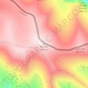
Mafadi topographic map
Click on the map to display elevation.
Thank you for supporting this site ❤️
Make a donation
Make a donation
Mafadi
By the Himalayan definition of a mountain, being a summit with at least 7% topographic prominence relative to height, Mafadi is not in fact a mountain summit, but rather a subsidiary summit of Makheka in Lesotho. By this definition, Champagne Castle is the highest mountain summit in South Africa, although Mafadi is unquestionably the highest point in South Africa.
Thank you for supporting this site ❤️
Make a donation
Make a donation
About this map
Name: Mafadi topographic map, elevation, terrain.
Location: Mafadi, Mokhotlong District, Lesotho (-29.20351 29.35847 -29.20341 29.35857)
Average elevation: 3,285 m
Minimum elevation: 2,837 m
Maximum elevation: 3,448 m
Thank you for supporting this site ❤️
Make a donation
Make a donation
Other topographic maps
Click on a map to view its topography, its elevation and its terrain.